


The Liverpool Projects consists of 4 Exploration Licences, totaling 1,239 km2 of highly prospective uranium gold, platinum and palladium ground located near the world class deposits of Ranger, Nabarlek, and Jabiluka Uranium Mines.
Ranger, Nabarlek, and Jabiluka Uranium Mines.
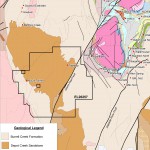
The Devil’s Elbow uranium-gold-palladium prospect located within EL27584, yielded high grade surface uranium assays of 3.2% U3O8, 3.7% U3O8, 4.40% U3O8 and 5.8% U3O8, with 38.1 g/t Au and 28.02 g/t Pd related to fractures within altered amygdaloidal basalt of the Nungbalgarri Volcanics. Abundant strong untested radiometric anomalies are hosted within the Gumarrinbang Sandstone which is considered prospective for unconformity related uranium mineralisation associated with gold and palladium.
unknown
unknown
unknown


- Iron Ore
- Northern Territory
- prospective for
iron ore, uranium, gold and base metals
- Iron Ore Project
- Northern Territory Australia.
- prospective for oolitic iron sedimentary deposits
- exploration target of 2 to 2.5 billion tonnes @ 40% to 60% Fe
- Iron Ore Project
- Queensland
- 176.4 sq km of Iron Bearing Lithology
[access role=buyer,administrator,buyerseller][purchase_link id="2016" text="Add to Cart" style="button" color="orange"][/access]
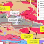
- The West McArthur River Project also hosts extensive electro-magnetic drill targets (10 EM drill targets which total of 135 sq km in total area) which are believe to host manganese mineralisation based on potential high grade manganese assay overlying electro-magnetic anomalies.
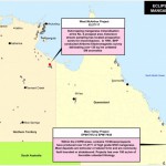
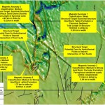
The Mary Valley Manganese Project is located approximately 14 road kilometres southwest of Gympie Township in Queensland. The largest mine on the tenements controlled by Eclipse Metals Ltd was at Amamoor No.1 Manganese Deposit (19,630t @ 51% Mn). The mine opened in 1920 and operated and then from 1960. Nearest port from the project is at Brisbane approximately 165 rail kilometres.
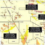
A total of 31,477 tonnes of ore was mined from the Mary Valley Project (within the 3 Exploration Permit Mineral areas) with the manganese grade ranging from 42% to 51% Mn with the limits of all the deposit not known either along strike or at depth.
Historical assays have also indicated that the Mn, Fe, Si and P levels are all within the direct shipping ore parameters which further confirm the economic potential of standalone mining operations over the Mary Valley Manganese Project. The project has 198 square kilometres of favorable lithology are present within the 2 Exploration Licence (EPM) areas.
Eclipse Uranium Project located entirely within the Ngalia Basin, 300km west northwest of Alice Springs and is proximal to the Bigrlyi uranium project (9 km NW of EL24808). The Bigryli deposit consists of 15 separate anomalies over a 14km strike length. The deposit has 9,660t contained uranium. The project covers 3,993 km2 of ground considered prospective for sandstone Bigrlyi style uranium mineralisation. There are several strong radiometric targets with the largest hosting a 3.62 km in strike by 2.69 in width anomaly similar to that on the Cappers Deposit (Inferred Resource 2,720t of U3O8, averaging 137 ppm U due east approximately 3.6 km from ELA24627 eastern tenement boundary.
The North Arunta Uranium Project consists of 6,120 km2 of highly prospective uranium ground with historical exploration delineating calcrete palaeochannels. The project hosts approximately 243 km2 of outcropping calcrete lithologies mapped by the Northern Territory Geological Survey. Future drilling may encountered anomalous uranium values at shallow levels over a distance in excess of several kilometres with the mineralisation associated with calcareous alluvium using the Napperby geological model deposit (9.34 Mt @ 359 ppm for 3,351 tonnes (7.39 Mlbs).
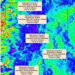
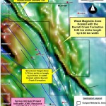
The Poiziers tenement (ELA 25666) is 757.6 sq km in total area and is wholly situated in the McArthur Basin. Historically the project has no uranium exploration thus a reconnaissance program should be implemented to assess the source of the radiometric anomalies. The Poiziers project review outlined moderate radiometric anomalies associated with Crawford Formation. Structural targets such as cross cutting faults associated with magnetic zones represent excellent drill targets within the Project area.

The South Alligator group of tenements consists 1,541.8 sq km and is situated in the Pine Creek Orogen and the McArthur Basin. The project area hosts extensive moderate to strong radiometric anomalies surrounded by uranium, base metal and gold prospects. The project areas are considered favourable to host vein-type deposits in which uranium minerals fill cracks, veins, fissures, pore spaces, breccias or stockworks, associated with steeply-dipping fault systems. Within the Edith River area uranium occurrances are related to steeply dipping north-northwest-trending shear zones within the greisenised Tennysons Leucogranite. Shear zones are up to 100 m wide and consist of a series of parallel quartz-filled shears (Kruse et al 1994). Mineralisation also occurs within tension fracture systems on the margins of shear zones. Autunite and minor torbernite are the main ore minerals, which occur as disseminations in haematitic breccia and coatings on joint and fracture planes (Gardner 1953a). Mineralisation at these prospects was only investigated to a depth of 10 cm and the primary uranium minerals are not known.
The Lambell Fault located in the east proportion of EL’s 26259 and 26260 represents a major structural target . The Grace Greek Granite geological model can be used as per the Edith River uranium prospects ie shear zones hosting uranium minerals within granitic intrusions. Other faults proximal to the Grace Creek Granite may represent high grade vein style uranium targets also.
Further work should also be concentrated on the ‘”South Anomaly” prospect to define the source of the radon. Geological mapping of the Kombolgie Sandstone and the fractured anticlinal axis should be targeted as a potential structure hosting uranium mineralisation.
The Flying Fox project is also hosted within Alligator River world-class uranium province. The review outlined a moderate to strong radiometric anomaly on the western portion of the EL associated with Diljin Hill Formation (medium to fine arenites) and the Mullaman Beds (ferruginous sandstone, conglomerate, quartz sandstone with residual sand cover). Approximately 25 km to the western portion of EL27703, the Writer and Spectre uranium prospects are hosted within the same lithologies ie the Diljin Hill Formation. This is highly encouraging as these radiometric anomalies may represent unconformity style uranium mineralisation.

The Gumadeer project is also hosted within Alligator River world-class uranium province. The review outlined a weak radiometric anomaly on the western portion of the Exploration Licence. The radiometric anomaly maybe derived from the Nimbuwah Complex contact with the Mamadawerre Sandstone.
• Gold Project
• Northern Territory Australia.
• prospective for sulphide-Au veins, shear hosted gold mineralisation
• exploration target of 10 to 20 million tonnes @ 1.5 to 3.0g/t Au